What Exactly Is a “Supercharged Wind Event?”
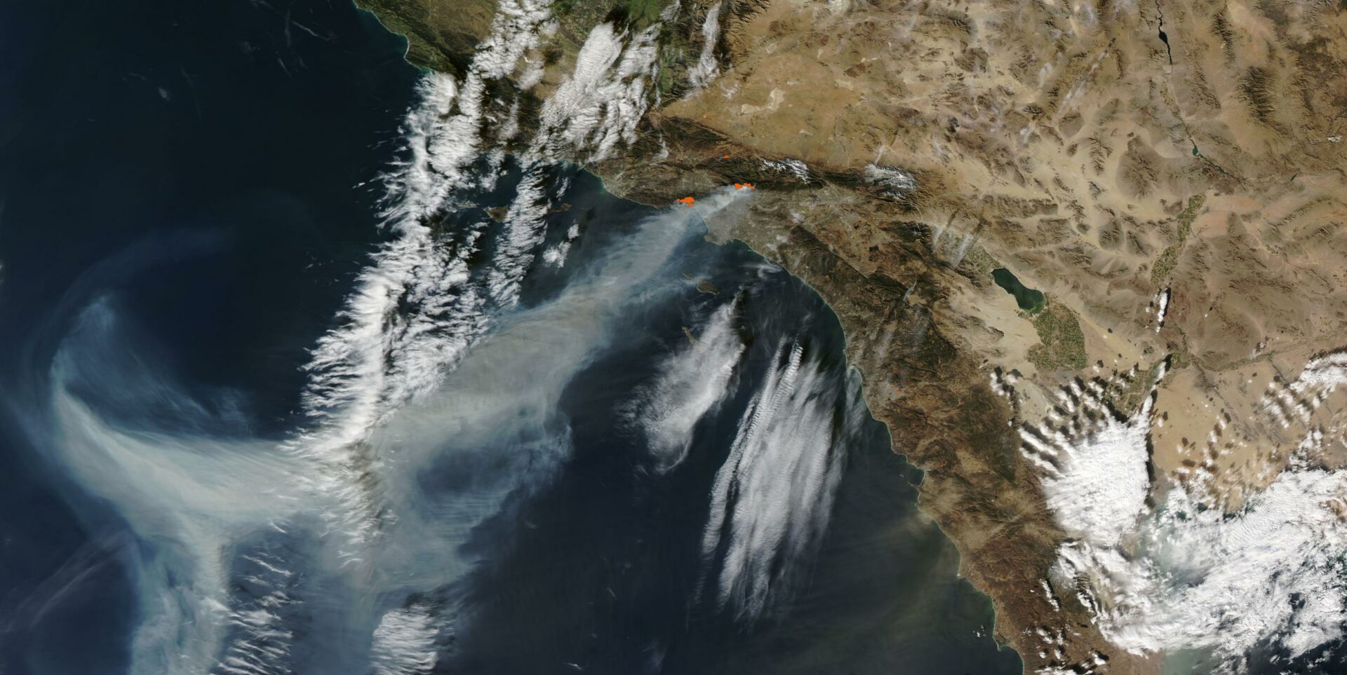
Image captured on Jan 8, 2025 of the Palisades and Eaton fires, from the NASA Worldview application.
In headlines about wildfire, a new supervillain emerges: wind. In January, it became the LA fires’ manic henchman, feeding it oxygen, sucking the moisture out of vegetation, and scooping up embers and throwing them miles away to seed new blazes that were impossible to predict. This was no ordinary wind: it was “supercharged,” characterized by gusts exceeding 90 mph.
What, exactly, is a “supercharged wind event”? “That is more of a media term,” says Brian Garcia, National Weather Service warning coordination meteorologist. It’s not a specific phenomenon: it’s a broad category that includes any event where winds are enhanced beyond typical conditions. The Bay Area experienced a notable supercharged wind event in January 2023 – our old friend the “bomb cyclone,” whose pouring rain precluded fire risk. In that case, winds were amplified by a rapid pressure decrease within the storm system.
In LA, the Santa Ana winds — hot, dry winds that sweep through Southern California, typically during autumn and winter — were the beneficiary of the “supercharge.” They’re strong, but they’re not usually this strong: in January, they were amplified by a powerful southwestward blast from the jet stream, which wasn’t where it was supposed to be. It’s likely that warming oceans are at the beginning of the domino effect that caused the jet stream to move off course. But the strong winds weren’t unprecedented – the region’s dryness was. LA had experienced near-zero rainfall for eight months, an extreme swing from two previous, wet winters.
Could this combination of phenomena hit the Bay Area? Yes and no. The Santa Anas aren’t a factor for us, but we get blown around by its northern cousin: the Diablo winds. Like the Santa Anas, the Diablo winds descend from high-pressure systems over Nevada in fall and winter, compressing and heating up as they funnel through the region’s mountain passes. They’ve been a factor in most major Bay Area fires, alongside dry winters: the 1991 Oakland Hills Fire, the 2017 North Bay Fires, and the 2018 Camp Fire were all whipped into a frenzy by the Diablos.
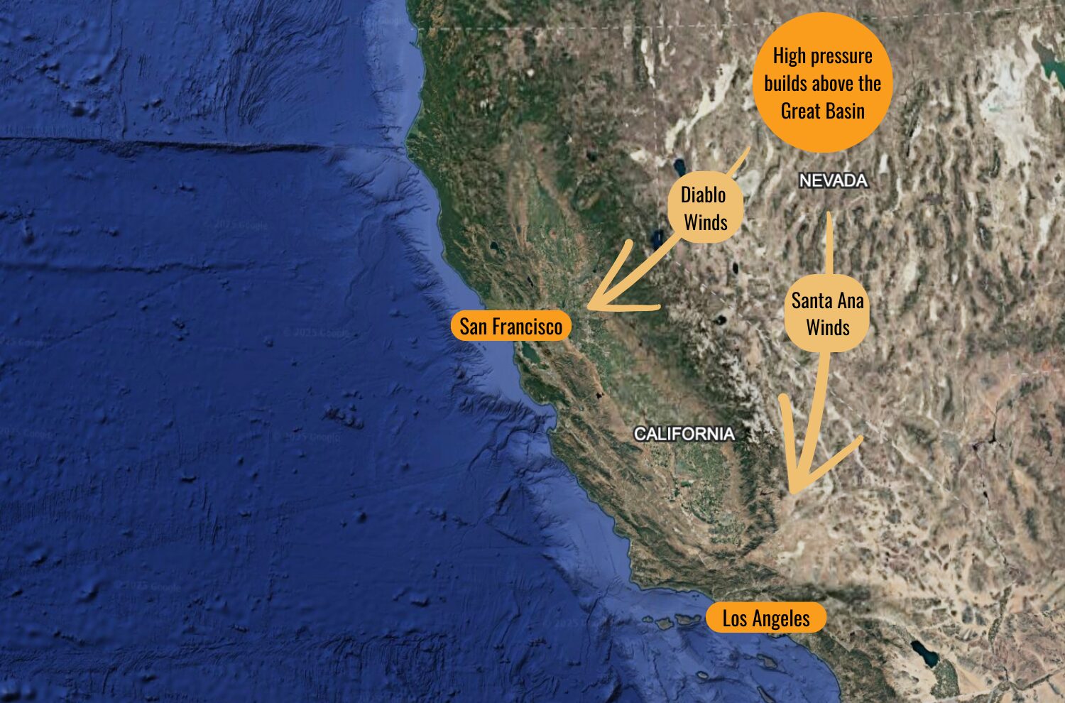
The Diablo and Santa Ana winds both send hot, dry air into California, usually in fall and winter.
How do we fight something so incorporeal? We can’t slow wind down – we can only prepare for it, and react to it. Wind, though swift and fickle, can be predictable. The NWS forecasted the strong LA winds days in advance, and issued red flag warnings. “The winds, for the most part, met the forecast expectations,” says Garcia. “Even the areas that they highlighted were really accurate. It was actually quite impressive.”
According to Garcia, the ability to predict high wind events is improving. He likens the forecasting process to a Wheel of Fortune puzzle board: “Back in the day, you may have had a glimpse of one or two letters, and now we have a glimpse at 80% of the letters. It’s a lot easier to make a much better, educated prediction on what’s actually going to happen.”
Of course, we have to know what to do with the forecast. One potential strategy is for electricity companies to figure out more precisely where and when to shut off power during gales, to help stop fires from starting in the first place. Another key research area is modeling how high-wind fires spread. Once the fire starts, normal firebreaks aren’t effective – burning fragments of wood can waft right over highways and creeks. When the wind picks up, the rules of wildfire change quickly. Garcia and NWS meteorologist Lamont Bain stress the importance of signing up for weather alerts from a trusted source, like AlertheBay.org.
And, you know, don’t start fires. Most blazes are human caused. So when the Red Flag is waving, “don’t do things that could spark a wildfire,” says Bain. “One less spark, one less flame.”
Other Recent Posts
Assistant Editor Job Announcement
Part time freelance job opening with Bay Area climate resilience magazine.
Training 18 New Community Leaders in a Resilience Hot Spot
A June 7 event minted 18 new community leaders now better-equipped to care for Suisun City and Fairfield through pollution, heat, smoke, and high water.
Mayor Pushes Suisun City To Do Better
Mayor Alma Hernandez has devoted herself to preparing her community for a warming world.
The Path to a Just Transition for Benicia’s Refinery Workers
As Valero prepares to shutter its Benicia oil refinery, 400 jobs hang in the balance. Can California ensure a just transition for fossil fuel workers?
Ecologist Finds Art in Restoring Levees
In Sacramento, an artist-ecologist brings California’s native species to life – through art, and through fish-friendly levee restoration.
New Metrics on Hybrid Gray-Green Levees
UC Santa Cruz research project investigates how horizontal “living levees” can cut flood risk.
Community Editor Job Announcement
Part time freelance job opening with Bay Area climate resilience magazine.

