Enough Mud to Fill 670 Skyscrapers?
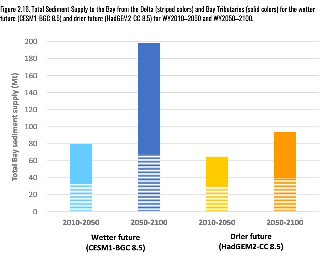
How much mud do we need to save Bay Area marshes from rising seas and how will we move it into position? If the future is drier there’s one answer, and if it’s wetter another (see chart), but the ballpark is 477,000,000 cubic yards. That’s the amount of sediment needed to sustain the ring of wetlands now protecting shoreline communities and infrastructure from a rising Bay, according to a new SF Estuary Institute report. Moving this much sediment into the right places–enough to fill the Sales Force skyscraper 670 times–will require the largest multi-decade public works project in the Bay Area’s history, says the Institute’s Warner Chabot. The report explores various nature-assisted methods of deploying the necessary material, ranging from spraying mud on the marsh surface and seeding it into the water column to placing it in the shallows near needy marshes. It also does a supply and demand breakdown, and reviews various sediment sources. Some, like dredged sediment now dumped at sea, are being wasted at a time when every grain is gold. Hard edges don’t have much flex when it comes to changing conditions, so climate-ready infrastructure needs to be softer and greener. Indeed, the local push to reinvent Bay Area shorelines defines exactly what Biden’s reimagined infrastructure for the 21st century is all about. Science-based solutions with an assist from nature.
Other Recent Posts
Slow Progress on Shade For California’s Hottest Desert Towns
Coachella Valley communities face record temperatures with little shade. Policy changes lag as local groups push for heat equity.
In Uncertain Times, the Port of Oakland Goes Electric
A $322M grant powers Oakland’s port electrification — cleaning air, cutting emissions, and investing in community justice.
Testing Adaptation Limits: Mariposa Trails, Marin Roads & San Francisco Greenspace
In KneeDeep’s new column, The Practice, we daylight how designers, engineers and planners are helping communities adapt to a changing climate.
ReaderBoard
Once a month we share reader announcements: jobs, events, reports, and more.
Boxes of Mud Could Tell a Hopeful Sediment Story
Scientists are testing whether dredged sediment placed in nearby shallows can help our wetlands keep pace with rising seas. Tiny tracers may reveal the answer.
“I Invite Everyone To Be a Scientist”
Plant tissue culture can help endangered species adapt to climate change. Amateur plant biologist Jasmine Neal’s community lab could make this tech more accessible.
How To Explain Extreme Weather Without the Fear Factor
Fear-based messaging about extreme weather can backfire. Here are some simple metaphors to explain climate change.
Live Near a Tiny Library? Join Our Citizen Marketing Campaign
KneeDeep asks readers to place paper zines in tiny street libraries to help us reach new folks.


