


How Rivers in the Sky Travel Across the Ocean
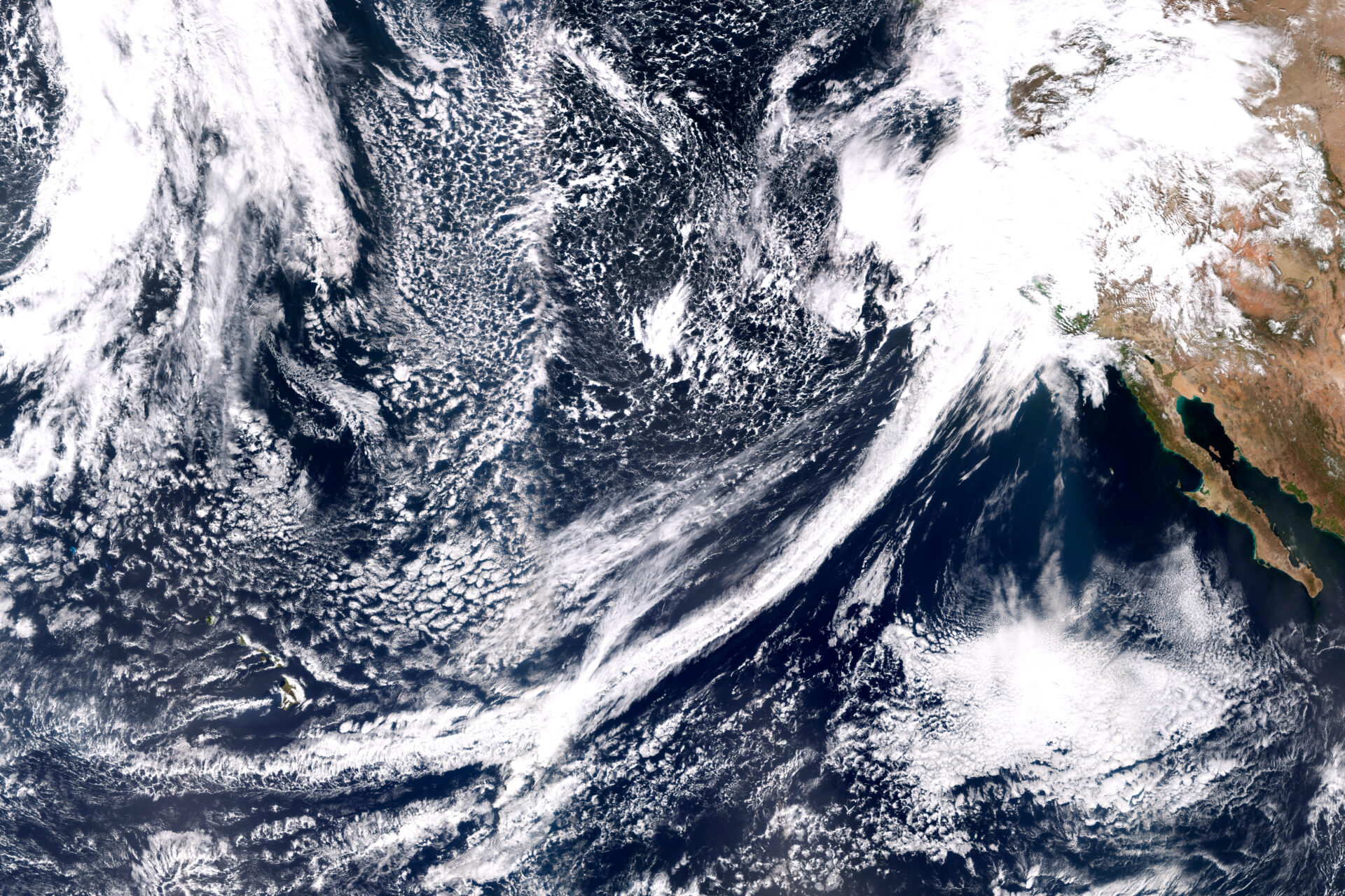
Winter in California is a time of promise and peril. We’re desperate for rain, only not too much please. Our fate swings from drought to floods, depending largely on whether or not we get rainstorms called atmospheric rivers. These ribbons of extraordinarily wet air shoot across the Pacific Ocean, dropping the moisture they carry upon landfall.
The Bay Area’s latest “wet” season began with the bang of a record-breaking atmospheric river in late October but then fizzled out. These storms have been so scarce in the last few months that the state is facing a third year of deepening drought.
Atmospheric rivers typically begin over oceans in the tropics, where it’s so warm that water evaporates readily, filling the air with moisture. Then all it takes to start an atmospheric river is a storm called an extratropical cyclone, which spins over the ocean and sweeps up the wet air.
“Atmospheric rivers are seeded by convection storms that move water vapor from the surface to a couple of kilometers high,” says Alan Rhoades, a hydroclimate scientist at Lawrence Berkeley National Laboratory.
Atmospheric rivers that form over the Pacific Ocean are then launched and propelled toward the West Coast by strong winds. “You need a driver like a low-level jet stream,” says Zhenhai Zhang, an atmospheric scientist at Scripps Institution of Oceanography. “The jet carries the moisture and moves fast in a narrow corridor.”
This airborne stream of water vapor then traverses a series of low and high pressure regions that are strung across the ocean. These regions set the path of the atmospheric river, which can be so long that it extends halfway across the Pacific. “A low grabs the water vapor and moves it northward, and a high then steers it toward the West Coast,” Rhoades says.
He likens this process to a conveyor belt, where the low and high pressure systems are like rollers that direct the atmospheric river. Another way to look at this process is that the low and high pressure areas are like the pegs of an enormous pinball machine, guiding and redirecting the flow of the atmospheric river and so shaping its trajectory toward land.
Other Recent Posts
Boxes of Mud Could Tell a Hopeful Sediment Story
Scientists are testing whether dredged sediment placed in nearby shallows can help our wetlands keep pace with rising seas. Tiny tracers may reveal the answer.
“I Invite Everyone To Be a Scientist”
Plant tissue culture can help endangered species adapt to climate change. Amateur plant biologist Jasmine Neal’s community lab could make this tech more accessible.
How To Explain Extreme Weather Without the Fear Factor
Fear-based messaging about extreme weather can backfire. Here are some simple metaphors to explain climate change.
Live Near a Tiny Library? Join Our Citizen Marketing Campaign
KneeDeep asks readers to place paper zines in tiny street libraries to help us reach new folks.
Join KneeDeep Times for Lightning Talks with 8 Local Reporters at SF Climate Week
Lightning Talks with 8 Reporters for SF Climate Week
ReaderBoard
Once a month we share reader announcements: jobs, events, reports, and more.
Staying Wise About Fire – 5 Years Post-CZU
As insurance companies pull out and wildfire seasons intensify, Santa Cruz County residents navigate the complexities of staying fire-ready.
Artist Christa Grenawalt Paints with Rain
Snippet of insight from the artist about her work.
High-Concept Plans for a High-Risk Shoreline
OneShoreline’s effort to shield the Millbrae-Burlingame shoreline from flooding has to balance cost, habitat, and airport safety.
In a Climate Disaster, Your Car Won’t Save You
Fleeing wildfires without a car might seem scary, but so is being trapped in evacuation gridlock — and the hellscape of car-dependency.

Instruments on this Sonoma County ridge measure precipitation, temperature, humidity, winds, barometric pressure, and more. Scientists use the data to connect the hydrology of the Russian River watershed to atmospheric river forecasts. Photo: Scripps, UCSD.
That trajectory is hard to predict, however. “Atmospheric rivers are often called whips or hoses because their path can shift in different directions,” Rhoades says. This is partly because these storms depend on wind, which changes from hour to hour. Atmospheric river speeds are difficult to pin down but may vary from 20 to 100 kilometers per hour.
And while the path can look fairly smooth at a global scale, up close it’s a different story. “At a small scale, it’s challenging to predict the exact path of an atmospheric river,” Zhang says, adding that an atmospheric river’s size, shape and intensity are also in flux.
Taken together, all this variability makes it hard to know exactly how strong an atmospheric river will be and exactly where it will make landfall. Another complication is that atmospheric rivers can be just a few hundred kilometers across. This is very close to the uncertainty in predictions of where they will hit, which can be off by a couple hundred kilometers. “That’s the difference between landfall in Los Angeles or in San Diego,” Zhang notes.


